
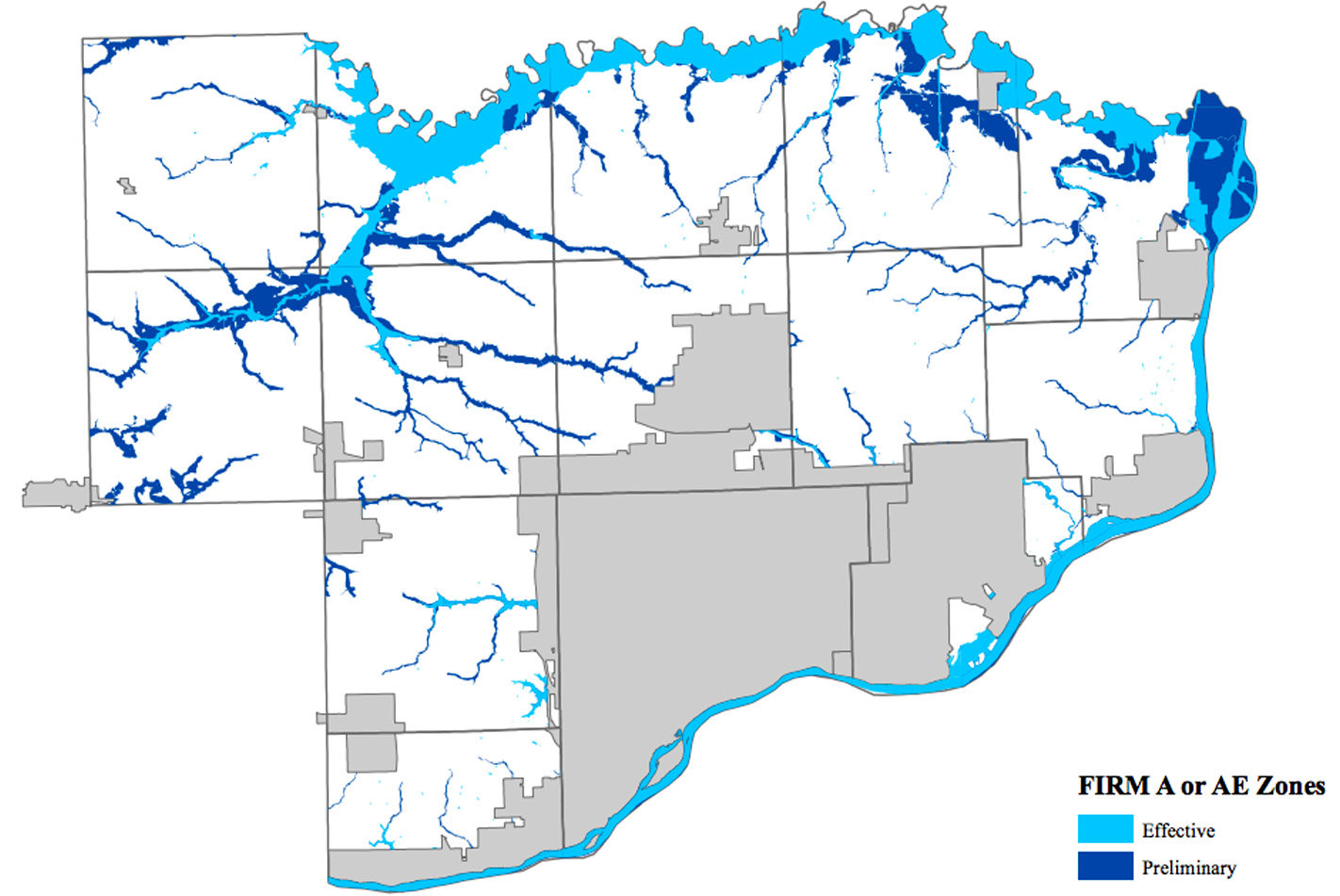
More than 14,000 acres of Scott County will be added to a FEMA flood plain map that will be the focus of a public meeting Aug. 29.
Most of those new acres are along Wapsi River and Mud Creek area farm fields, where residents already have experienced periodic flooding, said Scott County Planning Director Tim Huey, who also serves as county flood plain manager.
The revised map shows a total of 32,000 Scott County acres in flood plains. The expanded flood plain also included wildlife refuge areas north of Princeton, and some rural creek areas identified by the most recent FEMA flood studies.
Property owners have through Oct. 8 to challenge changes to the new map by appealing to the Scott County Planning Department.
“The sole basis for such appeals is possession of knowledge or technical information indicating that the proposed flood hazard determinations are incorrect,” Huey wrote in a memo to county supervisors.
“The flood study really looked at all the creeks in rural Scott County. Previously, many that do flood have not been designated as flood plain areas due to lack of study,” Huey said.
For example, Hickory Creek was in an identified flood plain in southwest Eldridge, but not in rural Sheridan and Hickory Grove townships.
The updated map is the fifth revision since FEMA first identified floodplains in 1978. The last update was in 2011.
The proposed map extends the Hickory Creek floodplain through those townships.
Huey said about 99 percent of the added flood plains cover land zoned for agriculture preservation, not residential or commercially zoned property.
“I would say of most of the added flood plain, the vast majority is corn and beans,” he said.
Landowners along Mud Creek will not be surprised by the flood plain expansion.
“It looks like Lost Grove Lake out there when there’s heavy rains, but it’s mostly farm fields,” Huey said.
Notices of the revised map have been mailed to about 330 landowners, Huey said.
“Most of the townships with added floodplain are the rural ones – Hickory Grove, Cleona, Sheridan – without much housing.”
Those living in the extended flood plains would need flood insurance to obtain a residential or commercial mortgage on any building.
“I’ve never had a farmer come in for a building permit in a flood plain,” Huey said, reflecting on more than 20 years as a Scott County planner.
Farmland owners would need a DNR permit for any excavation or levee work in a flood plain.
The open house is 6-8 p.m., Aug. 29 at the Scott County Administration Center, 600 W. 4th St., Davenport. Representatives from Scott County, the Iowa Department of Natural Resources, FEMA and the University of Iowa’s Iowa Flood Center will be there.
Huey said county residents can review the maps, ask questions and learn about implications of the new map. He said the county must adopt the map to allow property owners to be eligible for flood insurance.
He also said flood plain exemptions negotiated under the old map will be accepted under the new map.
Find a link to more information and copies of the current and proposed flood plain maps with this story at northscottpress.com.